News for winter 2021. The newsletter describes our new hourly PFD and convergence chart, which simplify the structuring of cross-country flight planning. There are also news about the cooperation with our partners.
TopMeteo Newsletter: 2021-12-14
Hourly PFD - Convergences - OLC - WeGlide - LXNAV
Gliding UpdateGliding Update
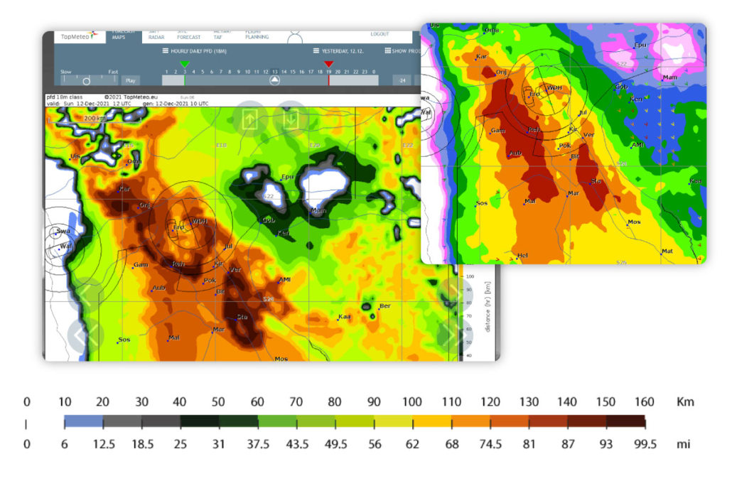
PFD chart hourly now!
Our classic PFD chart is now also available in hourly resolution. This gives a very good indication of the quality of the cross-country weather over day. The map is helpful, for example, when planning the first leg. It helps to answer the question in which direction you should fly first.
If the map does not appear, click on SHOW ALL PRODUCTS.
Convergence lines - the new map from TopMeteo
Just in time for the current season, we are introducing our specially developed convergence chart, initially for Africa (Namibia, South Africa, Botswana). If the results are satisfactory, the chart will also come for Europe and the US.
We have experimented a lot to make the chart usable for typical cross-country flying. There are many convergences, but most of them are not flyable for pilots. In combination with the 10m wind and the cloud distribution, a precise and accurate visualisation is possible.
Soon the chart will also be available in the app, so you can plan with updated forecasts while still in flight.
If the map does not appear, click on SHOW ALL PRODUCTS.
Neuigkeiten bei unseren Partnerschaften
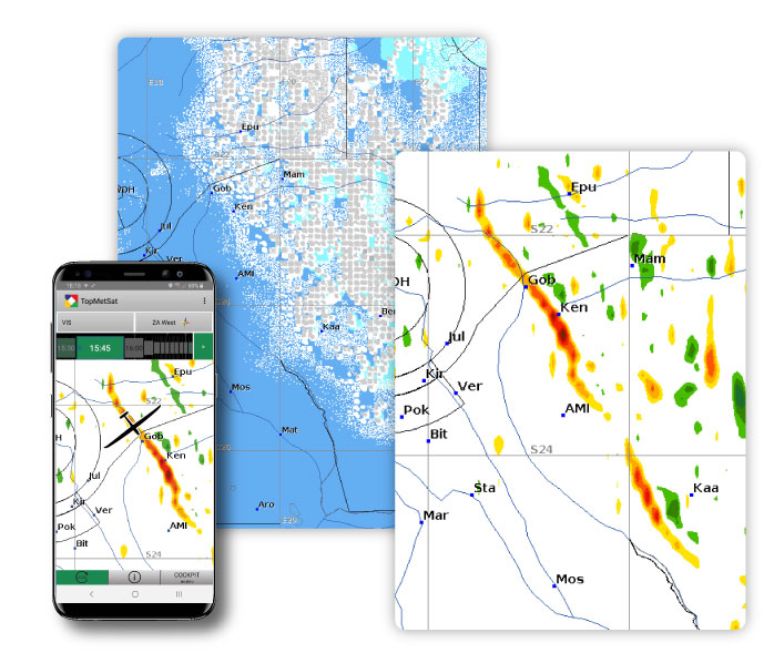
Our long-standing and friendly cooperation with the OLC has been further expanded. Since a few weeks, the OLC shows our satellite images as a layer in the new OLC map. For logged-in OLC users, the images are available in a 15-minute resolution.
A feature that makes the analysis of cross-country flights much easier. For a view of the flight path in the “current” weather.
New on the scene and thus also a new partner for us: WeGlide. Since this winter, the young team has also been displaying our satellite images in Africa and thus allows exciting “flying along” in live tracking.
Moritz from WeGlide had a talk with Bernd Goretzki (the head of TopMeteo). You can find the interview in our TopMeteo blog.
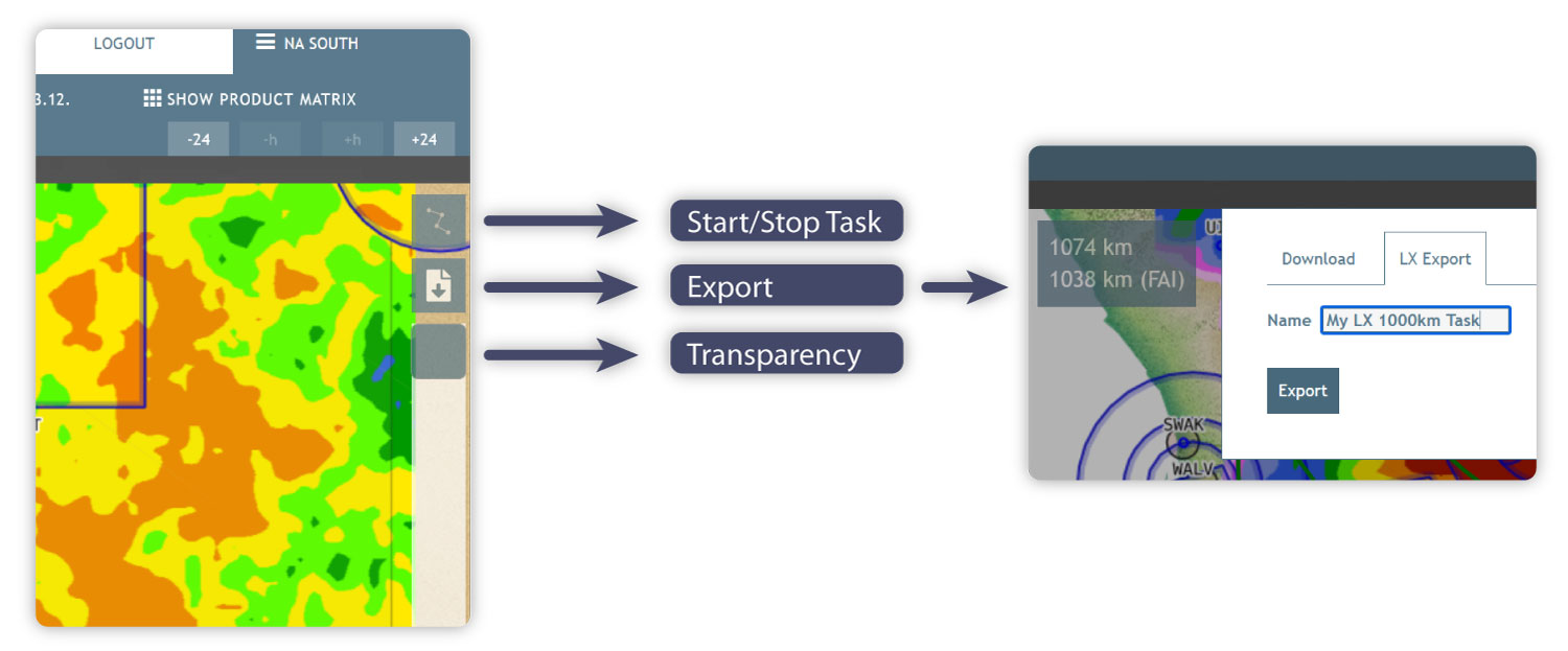
We have also had a close partnership with LXNAV from Slovenia for years. In the LXNAV devices, our forecasts can be displayed in the cockpit and current VIS satellite images can be loaded directly into the flight navigation.
In our flight planning there is a possibility to export planned tasks directly to LXNAV.
https://blog.topmeteo.eu/wp-content/uploads/2021/12/convergence-1.jpg589698Stefan Goretzkihttps://blog.topmeteo.eu/wp-content/uploads/2018/11/LogoTrans_600-1.pngStefan Goretzki2021-12-15 11:51:472021-12-15 17:12:18TopMeteo Newsletter December 2021
We can request cookies set on your device. We use cookies to communicate with you when you visit our Web sites, how you interact with us, improve your experience, and customize your relationship with our Web site.
Click on the different category headings to find out more. You can also change some of your settings. Keep in mind that blocking some types of cookies can affect your experience on our websites and the services we can offer.
Important website cookies
These cookies are essential in order to provide you with the services available on our website and to use some of their functions.
Since these cookies are essential to provide the site, you can not decline them without affecting the way our site works. You can block or delete them by changing your browser settings and forcing blocking all cookies on this site.
Google Analytics Cookies
These cookies collect information that is used either in aggregate form to understand how our website is used or how effective our marketing campaigns are, or to help us customize our website and application for you to improve your experience.
If you do not want us to track your visit to our website, you can disable tracking in your browser here:
Data Protection Policy
You can read our cookies and privacy settings in detail on our privacy policy.

 Bernd Goretzki
 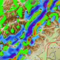 TopMeteo Lee Waves for Central Europe