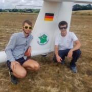
Interview of Clément Corbillé and Ludovic Mondésert who did a “Tour de France” in glider.

In our series, the TopMeteo pilots, we interviewed Clément Corbillé and Ludovic Mondésert, two French glider pilots about itinerant gliding. Indeed, last year, the two friends used an LS6 to do a “Tour de France”: one was piloting and the other was in charge of the car and trailer. Delighted by their experience they would like to see bigger this year and TopMeteo is happy to accompany them again.

Hello, thank you for this interview. Could you start by introducing yourself?

Clément: My name is Clément Corbillé and I’m 22 years old. I am a student in an engineering school in Tarbes named ENIT  in my 4th year. And otherwise, on the aeronautical side, I started gliding very early, around 2010, because my dad is a glider pilot and is in charge of the club of Graulhet in the Tarn area (south west France) called ATVV (Association Tarnaise de Vol à Voile). Since then I have flown a lot, mainly in glider and I have been instructor for 3 seasons now. I have a little bit more than 1500 hours and I do a lot of cross-country, mainly doing long flights for the Netcoupe (the “French OLC” based essentially on cumulative distance flights). I am a competitor, too. I’ve done a lot of competitions, even if it’s not what I prefer. I better like this type of flights we made in this “Tour de France”, I mean long flights. We can also say that we are both involved in a very active Youth glider pilots Club which brings together young pilots from the south-west of France. It is called SWAF (South West Air Force, it is also a homonym of “Soif” in French meaning Thirst).

Ludo: Ok, so, I’m 23 years old. I started flying in Toulouse, at the Bourg St Bernard Club called AVAT (Association Vélivole et Aéronautique Toulousaine) in 2012, by luck. I always wanted to be an airline pilot, but I didn’t start for that. In addition, I discovered other jobs, so I changed my mind and decided to become air traffic controller. I’m going to graduate soon and for the past year I’ve been working in the aera control center at the CRNA Est (Centre en Route de Navigation Aérienne Est) based in Reims (which manages the airspace in the north east of France) and I’ve been flying at the Club of Châlons-en-Champagne (which should have normally hosted the World Gliding Championship in August 2020). I go cross-country as soon as I can. I’ve done a little bit of competitions like Clément: Two French junior nationals and some regional competitions. I didn’t go there with the goal of winning, but more because it was interesting. It was also a good opportunity to fly elsewhere with other pilots and to improve my flying skills. But since I discovered the itinerant gliding last summer by flying around France with Clément, I know that it is that form of gliding that I prefer. No question.

Can you tell us more about your first “Tour de France”?

Clément : We have been thinking about it for several years. But between everyone’s availability and the experience we wanted to acquire before starting it, it only came up last summer. The objective was both to experiment new things and to discover a new type of flight. We also wanted to make people talk about gliding and itinerant gliding. To show that you can make beautiful flights and that gliding is not limited to tasks where you come back every day to your home field.

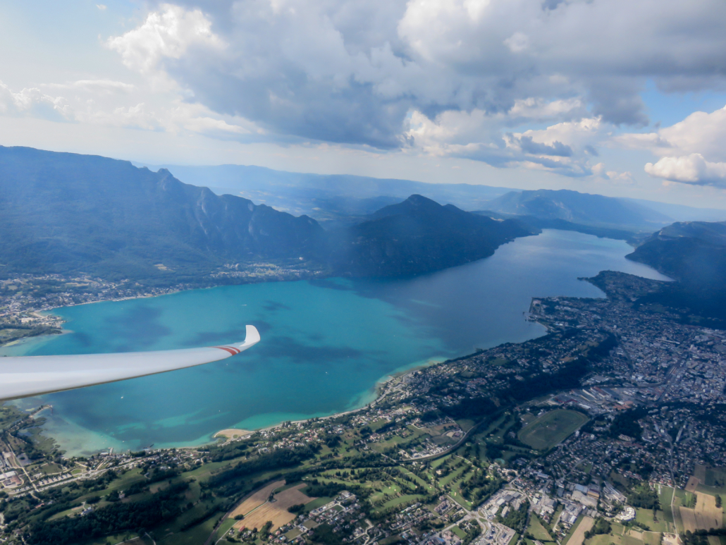
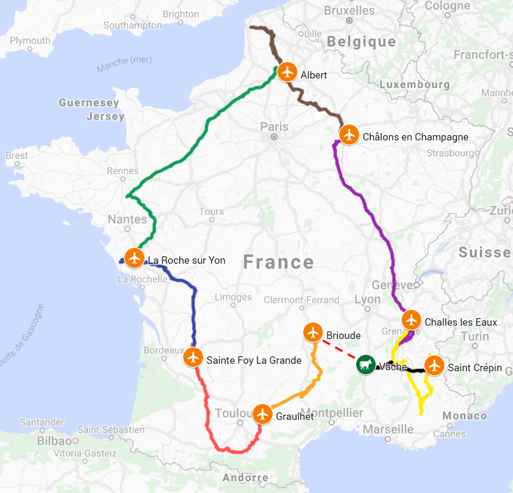
Ludo: So we set off: We did 8 stages, 4 flights each. Graulhet to Sainte Foy la Grande in the South-West, then we went up to La Roche sur Yon (west France) then we joined Albert (north Paris), Chalons en Champagne (east Paris), Challes-Les-Eaux (north west part of French Alps), St-Crépin (central French Alps), then we wanted to reach Brioude in the Massif Central but the crossing of the Rhone valley ended with an outlanding near Montelimar. So we joined Brioude by car. Finally, we went back to Graulhet to finish the loop. In total we flew 3003km.

Clément: We also met a lot of people. Every time we stopped we had a very warm welcome.  On top of that, we talked to many people from different clubs, by message, on the phone. They gave us advises and information about the availability of their clubs. So yes, we met a great welcome.

At what points were your journeys organized in advance?

Clément: It was planned in a way that we had the logistics ready. We had the glider, the car, the trailer. For the rest, we had some idea of where we wanted to go, which club we would like to visit. We were thinking the night before the flight: “okay, we’ve got this weather. We think we can go that far. On this road, we’ve got these clubs, and if it’s really good we can get further up to that airfield”. And so, every time like this. Then we contacted the clubs where we could potentially land as we needed to make sure that we would be able to take off again from this selection of airfields. Then, on the day, depending on the pilot feeling, we kept in touch, and adapted the strategy. Sometimes it was a much longer flight than we could imagine. So, it wasn’t fully predictable but there was a plan. We were never 100% sure where we’d land. But it worked quite well.

Ludo: The weather analysis part was important to us. Topmeteo had already sponsored us and so we were looking at the weather forecast and its evolution for the two or three days before to plan the best possible in advance. This helped to have a “big plan” and then the day before, we checked again and obviously, again just before take-off. We were pleasantly surprised by the result. It fit in well with what happened. I remember the Albert to Châlons flight, via Boulogne sur Mer. We’d seen that there would be a spread out on the return leg from Boulogne sur Mer leg. And it was exactly as planned: I struggled for a while, but fortunately, as planned, the weather improved after Albert.

Clément: We had really good use of the service. In Club, we rarely look at the forecasts more than 200km away from our course, whereas we used a lot of the Central European and French maps to anticipate the weather. Even though we had a great week, we were always ahead of poor condition. So we really needed to anticipate. For example, for the flight to Albert: we knew that Normandy wasn’t expected to have a good weather for the following days so we needed to go further and join Albert (north of France). And indeed, we would certainly have lost a lot of time if we hadn’t done that.

What surprised you most doing itinerant gliding?

Ludo: The really interesting part was flying to a lot of places in France very quickly. Because of this, we met a lot of different aerologies in a few days. We went from plains to mountains. And even between two different plains it was not the same conditions: it makes you wonder about the margin of progress that you have, due to local specificities. I remember the flight between Challes and St-Crépin (in the Alpes), I had already flown quite a bit in the Pyrenees, a bit in St-Auban but I still don’t think I have a lot of mountain flying experience. It was interesting to see how much more comfortable I am in the plains (smile).

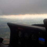
Clément: The other thing is that we didn’t have to come back to the departure point, so it opened up a lot of possibilities. If we had to go home in the evening, we wouldn’t venture as far in weather that seemed more or less insubstantial to us. During the “Tour de France”, we had the constraint of moving forward, and we knew that if we ever ended up in a field, the car would come to retrieve us, no matter what. Well, it allowed us to explore the weather that at first glance did not seem very welcoming, and finally we realized it was working. So, in terms of thermal experience, it was great. For example, the flight from La Roche sur Yon to Albert, when at the end, the sky was totally grey, we contacted Albert to tell them that I was about to arrive, they didn’t believe it. It was raining on the ground!

Ludo: When I told them we wanted to come to their airfield, they laughed! They said, “You’ll never make it, it’s not possible.”

Clément: So that opens up new perspectives. It allows us to make flights that we would never do if we had to go home.

Did you try TopMetSat?

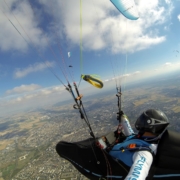
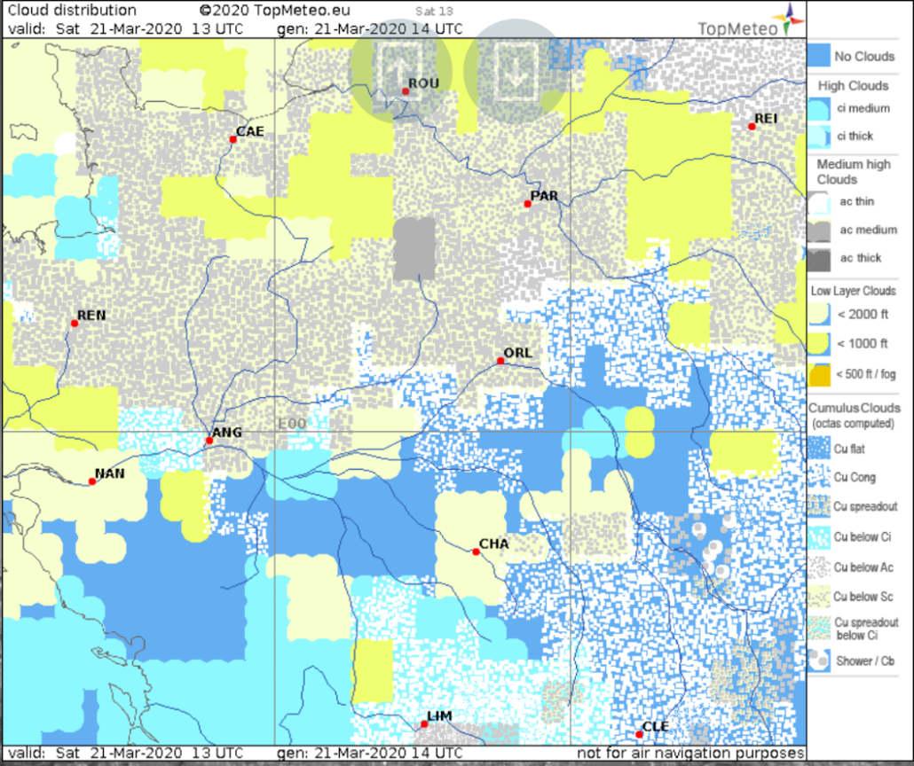
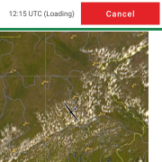
Ludo: Yes, on the flight to Albert, we were looking at the satellite images. With the loop mode. We could see the rain front being evacuated as Clement moved forward. It was good to have that confirmation.

What is your favourite Topmeteo product?

Clément: From my point of view, I like to start straight with the PFD (
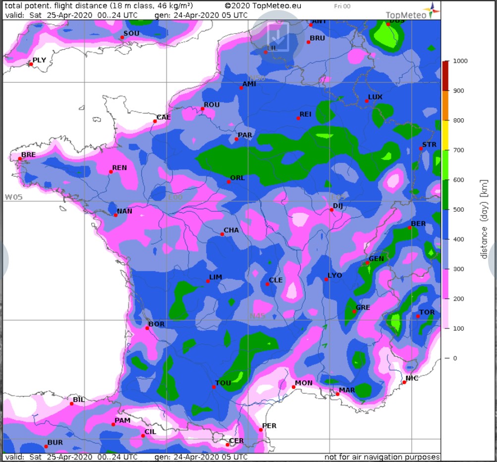
Potential Flight Distance
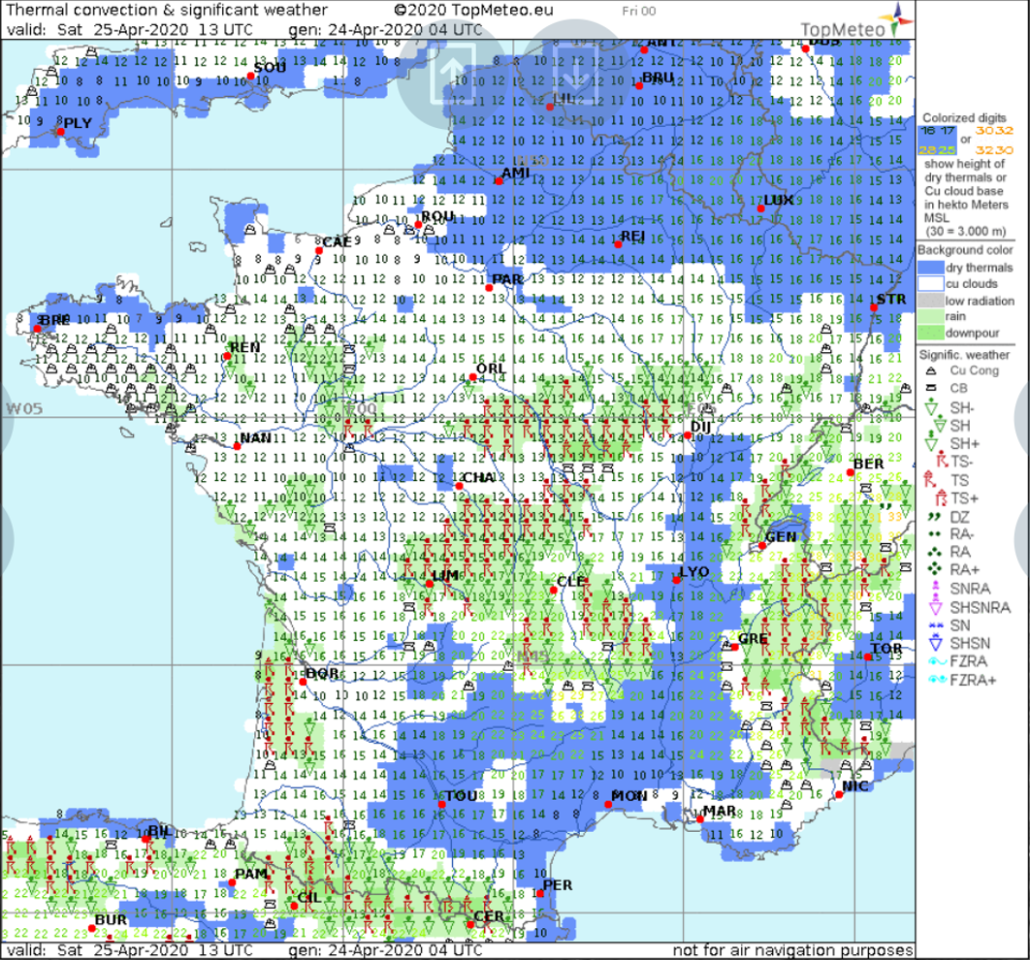
) map, just to have an idea if it’s going to be good or not… This gives a first and easy overview. Afterwards, I naturally check the details of the different maps. My tips: I only use the 18 meters map even if I am flying club class, because what interests me is knowing which sectors will be better, and I find that it has more contrast on the 18 meters map.

Ludo: Same, I use the PFD first and then I display the Thermals map and the one with the cloud cover to check from “where” does the PFD “come from”. And then when I have an idea of where I want to go, I look precisely at the airfields on the route to see the expected conditions at the time I think I will fly there.

And if you had to name the next development, what would it be?

Clément: Ah, I have a thing. It would be nice to have the wave forecast. I don’t do a lot of wave flying but from time to time when I go to the Pyrenees, it would be nice.

We know other pilots are asking for it and we work on it. As usual it takes time to finalise a product we are really happy and proud about. So, we cannot say when it will be available, but we are working on it.

So now, what’s the plan for this year… if the restrictions linked to COVID-19 are removed by July?

Ludo: Last summer we stayed in France. We had an idea of the different clubs we wanted to visit. We did it in 8 days, whereas we had planned to do it in two weeks. Well, we had great weather, but all in all it went so well…  This summer we’re are planning to give ourselves another two weeks, but then why not trying to go a bit further if the weather is good and we are allowed to do it? For example, we have never been in Spain. We heard about it : Pilots tell us about the great conditions there so why not crossing the Pyrenees and go to Spain to see some high cloud bases ? That’s a first idea. And then, depending on the weather and the COVID, why not taking a little trip to Germany? So yes, why not a “Tour de France” but from the outside?…

Clément: So, for today, we have no clear plan about where to stop yet, but the desire to go a little bit further is clear, still promoting the itinerant gliding. And obviously, trying to have a maximum of great experiences and adventures to share during and to tell afterwards.

Ludo: So yes, nothing planed but the desire to go further. And if all goes well, we will have a very nice glider to help us but nothing is signed yet.

What do you mean by that?

Clément: We talked with Schempp-Hirth and we could use their Discus2c- Fes. It would be super cool.

Ludo: That could be nice because it reduces the likelihood of outland. We can plan longer flights and then on certain stages, we can leave the trailer. It would be good to get rid of that weight for two or three days.

Clément: Yes, the FES will allow us to make more audacious flights. It will open up a new field of possibilities for us: not flying where we cannot land as it is still a glider but just being able to “skip” areas where the airmass is “dead”. It would be great if it’s confirmed.

Ludo: But the goal will still be not to turn the engine on!

Do you want to add something?

Clément: If some people are thinking of trying out itinerant gliding… There are a lot of constraints at first glance, but you have to give yourself the resources because it’s different from gliding in a club or in a competition, and it’s really amazing!

We keep our fingers crossed that you can do your “oversized Tour de France” this year, and we are proud to support you. Thanks again for the interview and for sharing your gliding adventures to the pilots but also to the public audience.

You can follow their aventure on Facebook and Instagram!

Interview of Martin Morlet: Exploration and Long distance paragliding flights

In our series “TopMeteo family pilots”, here is an interview with Martin Molet who, with friends, explores new spots around the world for long distance flights with paragliders.

Hello Martin, can you introduce yourself?

I started paragliding quite a long time ago, at the end of the 90’s. I learned to fly in a Parisian school called “Propulsion”, using the flatland’s spots that we have around Paris: in Normandy, in Burgundy, … Obviously, it would have been slightly easier in a mountain area. Near Paris, we are flying on hills that are only 50-100 meters high. But I quickly got the cross-country bug. Indeed, shortly after starting, I had the opportunity to climb to the cloud base. I had seen before in magazines that some pilots were covering distances like that, so I thought: let’s give it a try! And just like that, I did my first cross-country flight. It’s been a long time, and I wouldn’t be able to tell you how much distance I’ve flown this day, but it had a huge impact and this appeal for cross country never left me. During my studies, I found the time to do national and international competitions (two World Cup events). However, I had to slow down, and even stop for some years as I worked abroad. But before that, I had the opportunity, with two other “acolytes”, Franck Arnaud and Julien Dauphin, to really develop cross-country flying over the French flatlands. I did the first 200k in 2003. Then it was Julien who, in 2005, did the first 300k, and then I did the first 400k in 2016, which was also the European foot launch record. I also have two FAI ratified European records: a straight distance to a declared goal of 272km, and, in 2017, a distance via 3 turn points of 372km. So here it is, a slightly jagged course but ready for new adventures…

Maxime Bellemin and Martin

Why did you choose to focus on distance flights and records?

Records, for me, are secondary. I didn’t think about them at first. I like cross-country flying. More exactly, what I like is gliding. Windsurfing was a passion when I was young, and now I am “windsurfing” another element, which is great! I really enjoy keeping this symbiosis with nature for as long as possible, all day long, it’s incredible. In a way, it definitely reminded of those years windsurfing, this time through the invisible, like a permanent wave where you try to pick up the next lift that will take you a little further… Being able to enjoy and absorb all the energy from the element, without even seeing it. Then, there is this spirit of the “line”: crossing a landscape, a region, sometimes places you know, but mostly unknown territory you discover. The contemplative spirit of flying is also incredible. But when you’re a pilot, it goes without saying.

A small technical question for me who am not (yet) a paraglider pilot, what are the characteristics of your wings?

I fly with a glider considered as one of the best: an Ozone Enzo3. In Europe, there are different certifications: EN-A, -B, -C, -D. The higher you get in the letters, the better the performance of the glider, but at the same time, the more delicate it can be. As you fly with an inflated structure, you are more sensitive to the hazards of the air. Performance gliders are harder to control than the beginner ones. My glider is a “CCC”. It is a certification specific to competition-oriented gliders. On this type of glider, we have a glide ratio at around 10, some say maybe a little bit more, 11. We fly at about 38kph[1]. The wing stalls at about 25kph and, you can reach roughly 60kph maximum using a speed bar. This control is activated with the foot and allows you to change the angle of attack/incidence of the wing to gain speed. The minimum sink rate is about 1 meter per second. We are miles away from sailplanes and hang gliders in that regard, but when we land, we fold up, put it back in the rucksack, and go for a walk with the glider on our back. It’s unbeatable.

Fred Delbós flying with Martin

What is the turn radius with a paraglider?

It’s a good thing you’re asking me that question because until now, it hasn’t been very well documented. We knew that some gliders circled wider than others, but not much more… Recently, with two friends, we developed a statistical app, called XC Analytics, that analyzes the IGC tracks. So now, I can give you a more precise answer. Depending on the pilot, most of the time we are between a 20 and 30-meter radius. At those tilt angles, we are at about 1.4m/s of sink rate or more.

In preparation for the interview, I was looking at the analysis you do of flying and I was very surprised to see that paraglider pilots can spend 10% of their time “looking for thermals”.  This seems huge to me.

It’s true, though. You have to put things in context a bit. In paragliding, we are less able to go looking for the next thermal far away. As a result, we are very often in search for a thermal. But we don’t necessarily see a big difference between good and very good pilots on the time spent here. In general, in paragliding competitions, we do not observe that the biggest differences are made in the climbs or looking for them. On the contrary, gliding well is absolutely critical. This is where we observe that the gaps widen. 

Exemple of flight analysis using XC Analytics

Your application helps pilots analyze their flights and see what points they have to work on. If you apply it to yourself, what do you get?

For me? That’s easy. I learned it very early on, through competitions. I’m more of an attacker. And I have a natural tendency to fly alone, to fly fast, and to fly ahead. Which, in general, is not always a good idea… It was useful for me at the beginning, coming from the flatlands, to be able to compete with the alpine pilots on their ground, but afterwards I had to rein in this nature a bit to reach the French top 10. During the cross-country flights on the flatlands, I often have to compel myself to decrease the level of risk I take according to the weather conditions. Don’t go too low. Keep the good varios at the middle and high levels, maximize the lines of energy. It’s not that you can’t take varios very close to the ground. It’s stressful but it works well with a paraglider. However, when you’re at the bottom, you have less choices. So this is usually what I need to keep in mind if I want to fly at my best. On the other hand, one of my strengths lies in managing the changes of rhythm during the flight. I usually have a good reading of the air mass, because I spent quite a lot of time learning about the weather.

I’m going to come back to the weather point, but I have a question about the glide. Do you use McCready speed?

Actually, no, not really. Because our performance range is very different from the gliders. Often, if you follow the McCready speed in paragliding, you might land way before the next cumulus! When I used to compete, and I don’t know if that’s still the case, we used to have “numbers” in our heads. We knew our GPS speed, we estimated the wind speed, the performance of our glider and the average varios over the day. With that, everybody had a way to estimate the appropriate speeds. At the moment, very good competition pilots only attack hard if the next thermal is well materialized, for example by other competitors. For my part, I find that Cochrane’s formula[2] is much more adapted to paragliding than the McCready one.

Jean Claude Deturche during training

How do you plan your flights?

That’s a very good question. I’d say planning is almost 80% of the job. It’s tough work because there are so many parameters to take into account. First of all, the weather. Because of our aircraft, we have a reduced flight range and we can only use a reduced spectrum of weather conditions: not too much wind, but a little bit anyway. We need good thermals, too. It is almost impossible for us to do wave flights because of the wind. Next, depending on the weather, we will choose our take-off location. We are not attached to an aerodrome and therefore the choice of the site is essential. It must be well oriented in relation to the wind. It also needs to be in the right area. Within a few kilometers, the weather can change and we don’t have the possibility to make a 20k glide to get to the right spot. So, the choice of the site according to the weather is absolutely critical. In addition, we have to take into account the airspace. Our gliders are not registered, which means it is in theory impossible for us to talk with the controllers and to enter most of the airspace types. So, very often, we have slalom between airspaces, sometimes flirting within tens of meters if needed… Therefore, we have to anticipate which line will be the best and how we will be able to get around the airspace. We do a lot of preparation work calling the control towers, consulting the NOTAMs, looking at the different airspaces. And if we do everything right, then you find on the right spot, with the right alignment of clouds, no zones, etc. A good pilot has to know how to prepare his flights and find the right lines. The performance as such is less important than preparation. For example, the day I did the first 400k, I was on a spot near Rouen and many of my friends were on another one, only a hundred kilometers away from me, near Caen, and they didn’t even get to cloud base…

So, the weather forecast is essential. What’s the parameter you’re looking at first?

Everyone has their own recipe. Mine’s starting to get complicated. Of course, it depends on your objective. For example, for a triangular circuit in the flatland, almost no wind is required. So, you need a towing platform (without wind, small sites are too risky). And a good air mass of course. The logic to optimize a paragliding triangle on the flatland is to ponder on the movement and rotation of the anticyclone, to benefit from the little wind available to get help on each branch. For big straight distances, we look for the site with the maximum wind, within acceptable limits, with the best air mass. When I say acceptable, I mean: 25 kph. We can go up to a little more than 30kph but it can be dangerous. I’ve been using TopMeteo for many years, so I am used to it. I can guess how the model reacts. I can confront it with other models but especially with reality! So, I track the evolution between the model and the real situation, to see if the model fits the reality. Sometimes I have to mix and extrapolate with different models, to have a clear idea of the positioning required for D-day. Now, I have my habits, and it goes pretty fast if you have a good routine. But, at the beginning, I spent a lot of time practicing.

You ever been caught out by the weather?

On the flatlands, never. The evolution of the weather is finer and also more readable. However, in competitions in the Alps, yes, it happened. For example, if the task director doesn’t anticipate on a strengthening of the valley breeze, or even of the general flow. It’s never a good experience. If the wind increases just by 10kph, you go from “practicable” to “dangerous”! Weather forecasting is essential in paragliding.

What is your favourite product at TopMeteo?

My favourite is very basic: cloud cover. In my opinion, TopMeteo has the best cloud cover forecasting service available on the market. And for us, once again, it has a very important impact to have an accurate vision of what’s going to happen. Even if TopMeteo, like the others, can be wrong, on cloud cover, TopMeteo is the most accurate and the one that is the least wrong, especially on good days. And for us, it’s a determining factor, so I’ve been a subscriber for a long time and I’ve always loved it. Can’t find better for cloud cover.

If you had to create the next TopMeteo service, what would you want?

If I have a criticism to make, it’s that I’d like to have more details on the prediction modes. Maybe some Skew-T forecasts? It’s not to improve the prediction, but to know more precisely why the model thinks that. I know it’s tricky request, because basically I’m asking to maybe reveal some of the proprietary overlay of TopMeteo, so I understand it’s a questionable request.

Otherwise, a lot of pilots would like to have a “varios map”. For my part, I would like to have access to the archives. We are preparing a big flight expedition somewhere in Europe and I would like to have access to the archives to be able to fine-tune the forecasts.

So can you tell us a little bit about your plans for 2020?

Ha-ha. It’s still in preparation, and I don’t want to say too much at the moment, but with my “acolytes” Fred Delbos, Maxime Bellemin and Jean Claude Deturche, we’re looking for places to do long distance flights, not too far from home. We are a great team: Fred is a pilot with whom I fly regularly. He took the French record from me last year. A very good pilot. Maxime is a seasoned competitor. He has been in the world cup for several years with very good results. He was several years among the 20 best pilots in the FAI ranking. Finally, Jean-Claude, is perhaps the least experienced pilot but he is already very strong, training in the flatlands with us. He always has this pleasant curiosity, and we can always rely on his smooth talk for our adventures.

Our project: until now, to make great flights, there has been Texas, South Africa, and recently Brazil. Awesome places. You have many five stars days there, where it is possible to break world records, but it’s far away and we already know the area. So we want to discover a new playground that hasn’t really been fully explored yet. We want to expand our horizons, discover new people, a new region, a different weather, and try new flying styles. We’re already preparing: contacting locals, looking at airspaces, spotting possible sites… We contacted TopMeteo to analyze the weather and compare their insights with our weather analysis/flight experiences… If everything goes as planned, we’ll be able to write a new article describing our adventures, and to share our discoveries.


[1] Speed without breaks or speed bar

[2] https://faculty.chicagobooth.edu/john.cochrane/soaring/docs/newmcred.pdf

TopMetSat – reconsidered gliding flight

On 19.08.2018 I took off for a tourist glider flight . This led me from Jena finally to Regensburg. While I was still digging in the warm air in the Vogtland TopMetSat showed me that it was much better developed south of the border to Bavaria. At the Fichtelgebirge I discovered a great Cumulus line in the satellite image at the northern edge of the Danube valley – nothing but there.

Trip to the AirRace, Budapest 2017

Travelling to the RedBull AirRace in Budapest is a great experience. Especially, if you fly there on your own.

Around the world in a glider

A real option close to Meppen, Emsland, Germany.

On 08.07.2018, one day after the successful completion of the Euroglide, I flew from Venlo into the Emsland. North of Meppen, at the old Hüntel power plant,  I was able to circumnavigate the world. Along the equator it was the fastest. With the South Pole, however, no pilot has yet taken up the challenge!